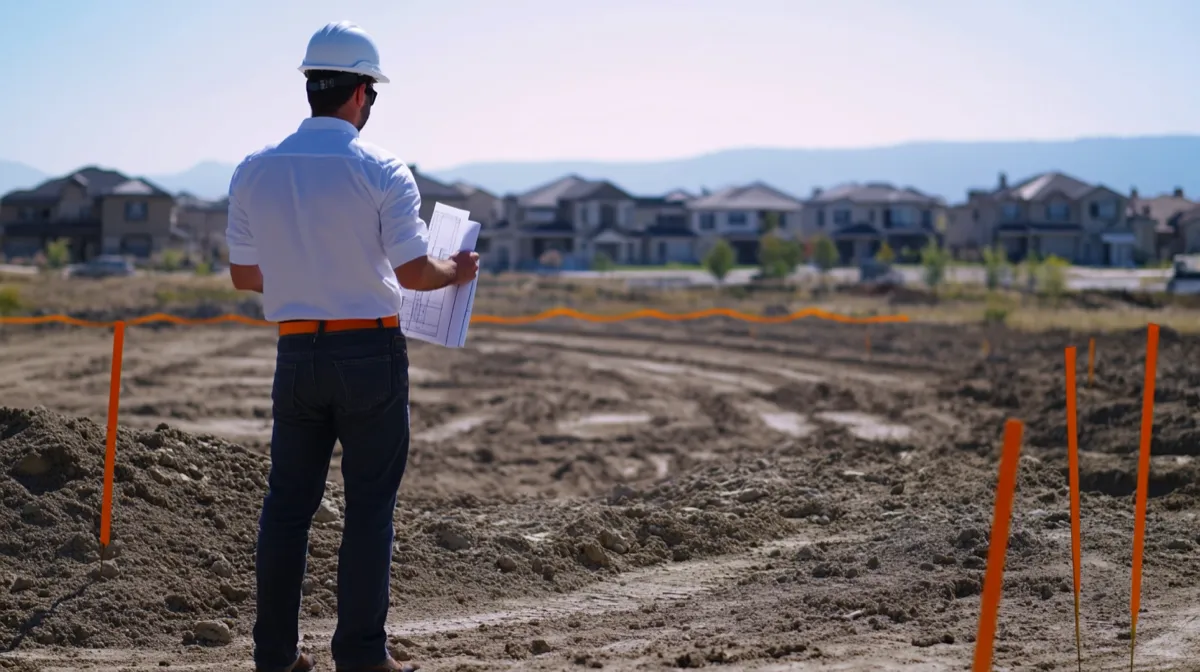
Why You Need to Export Your Land Measurements
You walked a property line with your iPhone, traced a field boundary, or dropped markers on key parcels. The measurement is saved on your device. Now what? Raw data sitting on a phone has limited value. The real power comes when you move that data into other software, share it with colleagues, submit it to a government office, or archive it for future reference.
Exporting transforms a mobile measurement into something portable and interoperable. A farmer can send field boundaries to a precision agriculture platform. A land surveyor can deliver parcel data to a client's GIS department. A real estate agent can attach a measured lot outline to a listing. A developer can feed coordinate data into a web mapping application.
The catch is that no single file format works everywhere. Google Earth speaks KML. GIS professionals expect Shapefiles. Web developers prefer GeoJSON. Outdoor enthusiasts rely on GPX. Clients who have never heard of any of these just want a PDF they can print.
Choosing the right export format saves time, avoids conversion headaches, and makes sure the recipient can actually use the data. This guide walks through every major geospatial format, explains when to use each one, and shows how to export from LandLens on iPhone and iPad.
Understanding Geospatial File Formats
Geospatial file formats store location data, specifically coordinates that define points, lines, and polygon boundaries on the Earth's surface. Each format was designed for a different era, audience, or software ecosystem. Some carry rich styling information. Others focus on raw geometry. Some are single self-contained files. Others are bundles of multiple companion files that must travel together.
The six formats most relevant to land measurement are KML, KMZ, Shapefile, GeoJSON, GPX, and PDF. The first five are true geospatial formats that preserve coordinate data in a machine-readable structure. PDF is a document format, but it is often the most practical choice when the audience is non-technical. Understanding the strengths and limitations of each format is the first step toward clean, efficient data workflows.
LandLens offers multiple professional export formats
KML and KMZ: The Google Earth Standard
What KML Is
KML stands for Keyhole Markup Language. It was originally developed by Keyhole, Inc., the company Google acquired in 2004 to build Google Earth. KML became an Open Geospatial Consortium (OGC) standard in 2008, which means it is not locked to Google products, but Google Earth remains its primary home.
At its core, KML is an XML-based text format. If you open a .kml file in any text editor, you will see structured tags defining placemarks, coordinates, polygon boundaries, line strings, styles (colors, line widths, fill opacity), labels, and descriptions. This human-readability is one of KML's underrated strengths: you can inspect the data, debug issues, and even make manual edits without specialized software.
KML Structure
A typical KML file for a land survey contains a <Document> element wrapping one or more <Placemark> elements. Each placemark holds a <Polygon>, <LineString>, or <Point> geometry with coordinates listed as longitude, latitude, and optionally altitude. Style elements control how the geometry renders visually in Google Earth, including boundary line color, fill color, and icon choices for point markers.
What KMZ Is
KMZ is simply a KML file compressed into a ZIP archive with a .kmz extension. It can also bundle embedded resources like images, custom icons, and ground overlays alongside the KML data. Because it is compressed, KMZ files are significantly smaller than their KML equivalents, making them better for email attachments and transfers over slow connections.
When to Use KML/KMZ
- Sharing with Google Earth users: KML and KMZ open natively in Google Earth and Google Earth Pro with full styling preserved.
- Presentations and visual demos: The styling capabilities make KML ideal for visually polished map overlays.
- Quick sharing via email: KMZ keeps file sizes small. A survey with hundreds of points might be under 50 KB.
- Cross-platform viewing: Google Earth is available on Windows, Mac, Linux, iOS, Android, and the web. Nearly anyone can open a KML file.
Limitations
KML is not the best choice for serious GIS analysis. While QGIS and ArcGIS can import KML, the format does not carry attribute tables, projection metadata, or topological relationships the way a Shapefile or GeoDatabase does. If your data needs to feed into spatial analysis pipelines, consider Shapefile or GeoJSON instead.
Shapefile: The GIS Industry Standard
What a Shapefile Actually Is
The Shapefile format was introduced by Esri in the early 1990s and quickly became the de facto standard for vector geospatial data. Despite its age, it remains the most universally supported format across GIS software. Virtually every GIS application on the planet, from ArcGIS Pro to open-source QGIS to niche industry tools, can read and write Shapefiles.
The key thing to understand about Shapefiles is that a "Shapefile" is not a single file. It is a bundle of at least three mandatory files, and often more:
- .shp - The main file storing the actual geometry (points, lines, polygons).
- .shx - A spatial index that speeds up geometry lookups. Required companion to the .shp file.
- .dbf - A dBASE table containing attribute data (area measurements, names, descriptions, metadata) linked to each geometric feature.
- .prj - A text file defining the coordinate reference system and map projection. Without this file, the GIS software may not know where on Earth the data belongs.
- .cpg - Character encoding file (optional, specifies text encoding for the .dbf attributes).
These files must stay together. If you send someone a .shp file without the .shx and .dbf, it will not open properly. LandLens handles this by exporting the Shapefile bundle as a single compressed archive, so all the component files travel together.
When to Use Shapefile
- Submitting to government land offices: Many municipalities, county assessors, and agricultural agencies require or prefer Shapefile format.
- Working with GIS professionals: If you are handing data to someone who works in ArcGIS, QGIS, or MapInfo, Shapefile is the safest bet.
- Spatial analysis: The attribute table (.dbf) allows you to carry rich metadata alongside geometry, enabling queries, joins, and analysis operations in GIS software.
- Archival and long-term storage: The format has been stable for over 30 years. Files created in 1995 still open perfectly today.
QGIS and ArcGIS Compatibility
Both QGIS (free, open-source) and ArcGIS Pro (commercial, industry standard) handle Shapefiles natively. You can drag and drop a Shapefile directly onto the map canvas in either application. The geometry renders immediately, and the attribute table is accessible for inspection and analysis. No plugins, no conversion steps, no configuration. It just works.
GeoJSON: The Developer-Friendly Format
What GeoJSON Is
GeoJSON is a geospatial data format based on JSON (JavaScript Object Notation), the lightweight data interchange format that powers most modern web APIs. Standardized as RFC 7946 in 2016, GeoJSON has become the default format for web-based mapping applications.
A GeoJSON file is a single, self-contained text file. No companion files, no bundles. Inside, you will find a FeatureCollection containing one or more Feature objects, each with a geometry (defining the shape) and a properties object (holding metadata like area, name, and measurement units). Coordinates are specified as arrays of [longitude, latitude] pairs.
Web Map Integration
GeoJSON's greatest strength is its seamless integration with web mapping libraries. Leaflet, Mapbox GL JS, OpenLayers, Google Maps JavaScript API, and Deck.gl all have native GeoJSON support. Loading a land survey onto a web map is often as simple as passing the GeoJSON object to a single function call.
GitHub has a particularly useful feature: drop a .geojson file into any repository and GitHub automatically renders it as an interactive map. This makes GeoJSON excellent for project documentation, data sharing in open-source projects, and code reviews that involve geographic data.
API and Database Usage
Because GeoJSON is valid JSON, it fits naturally into REST APIs and database storage. PostgreSQL with the PostGIS extension can store and query GeoJSON geometry directly. MongoDB has native geospatial indexing for GeoJSON objects. If you are building a land management system, farm mapping platform, or any application that needs to store and serve geographic data, GeoJSON is the most natural format for data exchange.
When to Use GeoJSON
- Web development: Building or feeding data into web-based maps.
- API integration: Sending land survey data to backend services or third-party platforms.
- Database storage: Storing survey data in PostgreSQL/PostGIS or MongoDB.
- Sharing on GitHub: Automatic map rendering in repositories.
- Cross-platform archival: Single-file, text-based, no proprietary dependencies, future-proof.
GPX: The GPS Exchange Format
What GPX Is
GPX (GPS Exchange Format) is an XML-based format designed specifically for GPS data. It stores three types of information: waypoints (individual named locations), tracks (sequences of points recording a path of travel over time), and routes (planned navigation paths). Each data point can include latitude, longitude, elevation, and a timestamp.
Track Data and Waypoints
The timestamp capability makes GPX unique among the formats discussed here. When you record a GPS track, each point records not just where you were, but when you were there. This is valuable for calculating travel speed, documenting the order of a boundary walk, and reconstructing fieldwork timelines. Waypoints serve as named bookmarks for significant locations, like property corners, gate locations, or reference points.
When to Use GPX
- Exchanging data with handheld GPS devices: Garmin, Magellan, and other dedicated GPS units use GPX as their primary interchange format.
- Hiking and outdoor recreation: Trail mapping apps, AllTrails, and outdoor platforms work natively with GPX.
- Importing boundary walks into other apps: If you recorded a perimeter walk with a GPS tracker, you can import the GPX track into LandLens to convert it into a measured area.
- Time-stamped documentation: When you need to prove exactly when a boundary was walked or a point was visited.
PDF Reports: For Clients and Documentation
When You Need a Non-Technical Format
PDF is not a geospatial format. You cannot import a PDF into QGIS or overlay it on Google Earth. But PDF solves a problem that none of the other formats address: communicating measurement results to people who do not have, and do not want to install, GIS software.
When a landowner asks "can you send me the measurement?", they want something they can open on their phone, read on their computer, or print and file. They want a document, not a data file. PDF delivers exactly that.
What a LandLens PDF Report Includes
- A map snapshot showing the measured area or distance overlaid on satellite imagery.
- Calculated measurements: area (in your chosen unit), perimeter, and individual segment lengths.
- Coordinate data for each boundary point.
- Measurement metadata: date, label, and any notes you attached.
- Clean, printable formatting suitable for filing, presentations, or client deliverables.
Practical Uses for PDF Exports
- Client reports: Real estate agents, land consultants, and surveyors sending results to clients.
- Legal documentation: Attaching measurement evidence to contracts, disputes, or filings.
- Permit applications: Some local offices accept printed or PDF measurement documentation.
- Internal records: Keeping a human-readable archive of fieldwork alongside the raw data files.
A practical tip: export both a GeoJSON (or Shapefile) and a PDF for every important measurement. The geospatial file preserves machine-readable data for technical use. The PDF preserves a human-readable record. Together, they cover every scenario.
Format Comparison Table
| Format | File Extension | Typical Size | Software Compatibility | Best For |
|---|---|---|---|---|
| KML | .kml | Medium | Google Earth, Google Maps, QGIS, ArcGIS | Visualization, Google Earth sharing |
| KMZ | .kmz | Small (compressed) | Same as KML | Email sharing, embedded imagery |
| Shapefile | .shp/.shx/.dbf/.prj | Medium | ArcGIS, QGIS, MapInfo, Global Mapper, virtually all GIS | Professional GIS, government submissions, spatial analysis |
| GeoJSON | .geojson / .json | Medium | QGIS, Mapbox, Leaflet, GitHub, web mapping libraries, modern GIS | Web development, APIs, database storage |
| GPX | .gpx | Small to Medium | Garmin devices, hiking apps, QGIS, Google Earth | GPS device exchange, outdoor recreation, track logging |
| Medium to Large | Any device, any browser, any PDF reader | Client reports, printed records, non-technical audiences |
How to Export from LandLens
LandLens makes exporting straightforward on iPhone and iPad. Here is the step-by-step process for each format.
General Export Steps
- Measure land area, distance, or drop a marker. Complete your measurement and save it. You need a saved measurement before you can export.
- Open the saved measurement. Navigate to the Saved tab and tap on the area, distance, or marker you want to export.
- Tap the export button. In the detail view, look for the export or share icon. This opens the format selection screen.
- Choose your format. Select from KML, KMZ, Shapefile, GeoJSON, or PDF. The file generates in seconds.
- Share or save. Use the iOS share sheet to send via email, AirDrop, iMessage, save to the Files app, upload to iCloud Drive, Dropbox, Google Drive, or open directly in another app on your device.
Exporting KML and KMZ
Select KML for an uncompressed XML file that you can inspect and edit in a text editor. Select KMZ for a compressed version that is smaller and better suited for email. Both formats preserve polygon styling, colors, and labels. The exported file is ready to open in Google Earth without any modification.
Exporting Shapefile
When you choose Shapefile, LandLens generates the full bundle of required files (.shp, .shx, .dbf, .prj) and compresses them into a single .zip archive. The recipient unzips the archive and opens the .shp file in their GIS software. The .prj file is set to WGS 84 (EPSG:4326), which is the standard GPS coordinate system.
Exporting GeoJSON
The GeoJSON export produces a single .geojson file containing all geometry and properties. No unzipping needed. The file can be opened directly in QGIS, uploaded to Mapbox, pasted into a web mapping script, or dropped into a GitHub repository for instant map rendering.
Exporting PDF
The PDF export generates a formatted report with a map snapshot, calculated measurements, coordinates, and metadata. It is optimized for readability and printing. Send it directly to a client, attach it to an email, or print it for physical filing.
Batch Exporting
LandLens supports exporting entire folders of measurements at once. If you have surveyed multiple fields, parcels, or property boundaries, you can select the folder and export all contained measurements in a single operation. This is particularly useful for delivering comprehensive survey packages to clients or uploading batches of data to a GIS system.
Opening Exported Files in Google Earth Pro, QGIS, and ArcGIS
Google Earth Pro
- Download and install Google Earth Pro (free).
- Go to File > Open, or simply double-click the .kml or .kmz file.
- The survey appears in the Places panel on the left. Click on it to zoom to the location.
- Right-click the placemark for options like editing style, viewing coordinates, or saving to My Places.
Google Earth Pro can also open GeoJSON and Shapefile data via the import function (File > Import), though KML/KMZ is the native and smoothest experience.
QGIS (Free, Open-Source)
- Download and install QGIS (free, available on Windows, Mac, and Linux).
- Open QGIS and drag the exported file (.shp, .geojson, .kml, or .gpx) directly onto the map canvas.
- The layer appears in the Layers panel. Right-click and select Open Attribute Table to view measurements and metadata.
- Use the Identify tool to click on features and inspect their properties.
- To reproject to a different coordinate system, right-click the layer > Export > Save Features As, and choose your target CRS.
QGIS is the best free option for working with exported land survey data. It handles every format LandLens exports and provides powerful tools for analysis, styling, and further export.
ArcGIS Pro
- Open ArcGIS Pro and create or open a project.
- In the Catalog pane, navigate to the folder containing your exported file.
- Drag the Shapefile or GeoJSON onto the map. For KML, use the KML To Layer geoprocessing tool (Conversion Tools > From KML).
- The data appears as a feature layer. Open the attribute table to view measurements.
- Use the Project tool in the Data Management toolbox if you need to reproject to a local coordinate system.
Importing Data into LandLens
Export is only half the story. LandLens also supports importing KML and GPX files, which means you can bring external data into the app for viewing, editing, and re-exporting.
What You Can Import
- KML files: Boundaries created in Google Earth, Google My Maps, or other mapping tools. LandLens reads the polygon, line, and point geometry and creates saved measurements from it.
- GPX files: GPS tracks from handheld devices (Garmin, etc.), hiking apps, or other GPS recording tools. Track points are imported and can be converted into measured areas or distance lines.
How to Import
- Get the KML or GPX file onto your iPhone or iPad. You can receive it via email, AirDrop, download it from cloud storage, or transfer it via the Files app.
- Tap the file and choose "Open in LandLens" from the share options, or open LandLens and use the import function.
- LandLens reads the geometry and creates saved measurements. Polygons become areas, line strings become distances, and points become markers.
- Once imported, you can view the data on the map, edit it, add it to folders, or re-export it in a different format.
Common Import Scenarios
- Colleague collaboration: A colleague measured a parcel using a different app and exported a KML. Import it into LandLens to view, verify, and re-export as a Shapefile for your GIS team.
- GPS device data: You recorded a boundary walk with a handheld Garmin GPS. Export the track as GPX, import into LandLens, and get area calculations along with the ability to export as KML, Shapefile, or PDF.
- Google Earth planning: You drew preliminary boundaries in Google Earth and saved as KML. Import into LandLens to get accurate area and perimeter measurements, then refine in the field using GPS accuracy techniques.
- Device migration: Moving to a new iPhone or iPad. Export your measurements as KML, transfer the file, and import on the new device.
Tips for Clean Exports
The quality of your export depends on the quality of your input. Here are practical tips for getting the best results from every exported file.
1. Name Your Measurements Before Exporting
A measurement labeled "North Field - Section 12" is infinitely more useful in Google Earth or QGIS than one labeled "Area 1" or left with the default name. Take a few seconds to add a descriptive name before exporting. The name carries over into KML placemarks, Shapefile attribute tables, GeoJSON properties, and PDF report headers.
2. Use Folders for Organization
If you are exporting multiple measurements, organize them into folders first. Folder-based exports maintain the grouping structure in KML (as nested folders in Google Earth) and keep batch exports tidy. This is especially valuable when delivering survey packages that cover multiple parcels or fields.
3. Check Your Boundary Closure
For area measurements, make sure your polygon is properly closed before exporting. An unclosed polygon can cause display issues in some GIS software. LandLens automatically closes polygons, but verifying the shape visually before export is good practice.
4. Be Aware of the Coordinate System
All LandLens exports use WGS 84 (EPSG:4326), the standard coordinate reference system used by GPS worldwide. This is what Google Earth, most web mapping tools, and the majority of GIS applications expect by default. If your target software or recipient requires a different projection, such as a local UTM zone, NAD83 state plane, or a national grid, you or they will need to reproject after import. QGIS and ArcGIS both handle reprojection with a few clicks.
5. Export Multiple Formats When Unsure
If you do not know what the recipient needs, export as both GeoJSON and PDF. The GeoJSON preserves full geospatial data for any technical use. The PDF provides a human-readable document for everyone else. Adding a KML gives you Google Earth coverage as well. LandLens makes it easy to export the same measurement in multiple formats, so there is no penalty for covering your bases.
6. Verify Your Export
After exporting, open the file in the target software to confirm everything looks correct. A quick check in Google Earth (for KML) or QGIS (for Shapefile/GeoJSON) catches issues before you deliver to a client or submit to an agency. This takes 30 seconds and can save you from embarrassment or rework.
7. Keep Raw Data Alongside Exports
Exported files are snapshots. If you later refine a boundary or correct a point, the previously exported files will not update. Keep your measurements saved in LandLens as the source of truth, and re-export when updates are made. This way, you always have the latest version ready to generate fresh exports.
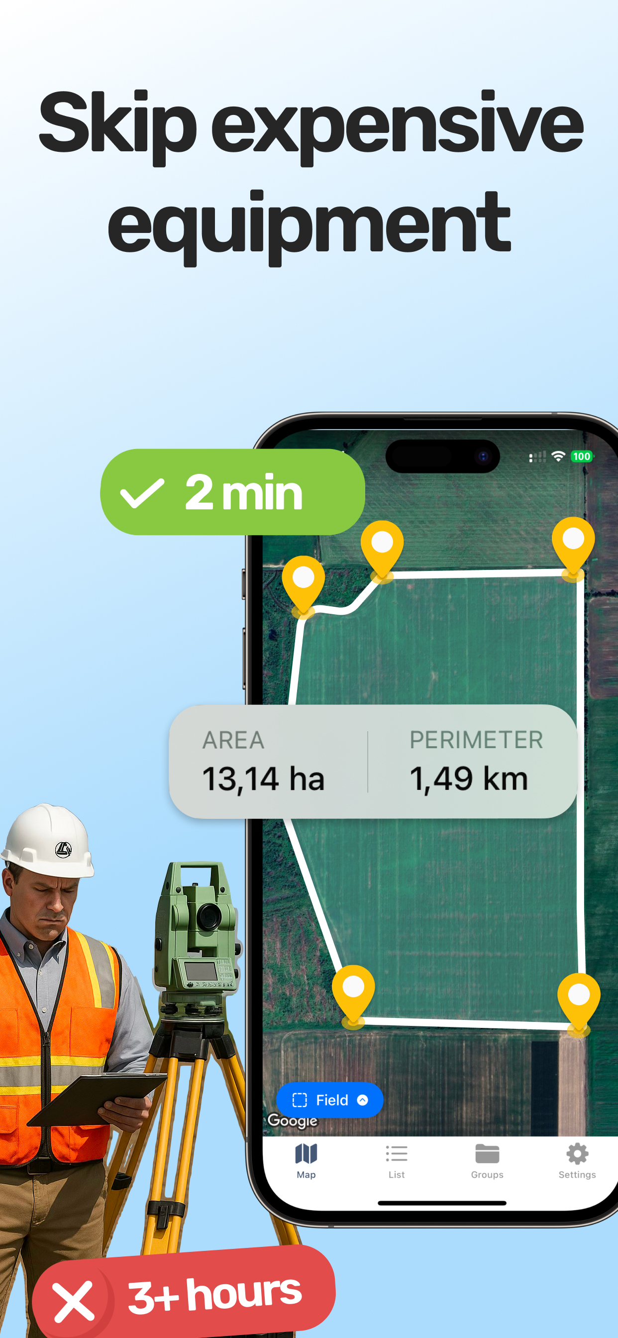
From Field to Software in Minutes
The workflow from GPS measurement to properly formatted geospatial file should be fast and friction-free. With LandLens, you can measure land area on your iPhone or iPad, save the measurement, and export it as KML, KMZ, Shapefile, GeoJSON, or PDF in under a minute. No transcribing coordinates by hand, no data entry into spreadsheets, no intermediate conversion steps. Measure, save, export, share.
Whether the data ends up in Google Earth for a visual presentation, QGIS for spatial analysis, ArcGIS for a professional GIS workflow, a web map for an online platform, or a printed PDF report for a client meeting, the right export format gets it there directly. Pick the format that matches your audience and destination software, follow the tips for clean exports, and the data will arrive ready to use.
Try LandLens free
Measure any land area, distance, or perimeter with your iPhone or iPad. No equipment needed.
Share Your Feedback
Help us build a better LandLens. Request features, report bugs, or tell us what you think.